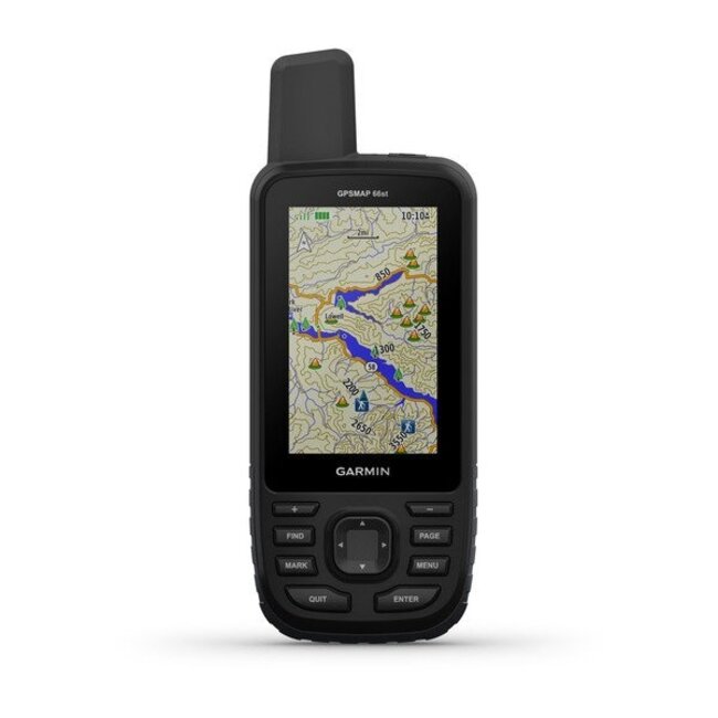


NAVIGATE YOUR NEXT ADVENTURE
Whether you’re hiking, hunting, climbing, geocaching, kayaking or mountain biking, explore more by using this premium, rugged handheld with a 3” color display and preloaded maps.
No squinting necessary with this large, sunlight-readable color display.
Multi-GNSS satellite support shows the way, and ABC sensors point you in the right direction.
Maps as pretty as a picture and just as detailed.
See the peaks and valleys clearly with TOPO maps for the U.S. and Canada.
Having Active Weather is like having your own personal weather forecaster on every journey.
Explore more with up to 16 hours of battery life in GPS mode and 1 week in Expedition mode.
General |
|
| PHYSICAL DIMENSIONS | 2.5" x 6.4" x 1.4" (6.2 x 16.3 x 3.5 cm) |
|---|---|
| DISPLAY SIZE | 1.5"W x 2.5"H (3.8 x 6.3 cm); 3" diag (7.6 cm) |
| DISPLAY RESOLUTION | 240 x 400 pixels |
| DISPLAY TYPE | transflective color TFT |
| WEIGHT |
8.1 oz (230 g) with batteries |
| BATTERY TYPE | 2 AA batteries (not included); NiMH or Lithium recommended |
| BATTERY LIFE |
Up to 16 hours |
| WATER RATING | IPX7 |
| MIL-STD-810 | yes (thermal, shock, water) |
| HIGH-SENSITIVITY RECEIVER | |
| INTERFACE | high speed micro USB and NMEA 0183 compatible |
| MEMORY/HISTORY | 16 GB (user space varies based on included mapping) |
Maps & Memory |
|
| PRELOADED MAPS |
yes (topographic 100k for U.S. and Canada, not routable) |
|---|---|
| ABILITY TO ADD MAPS | |
| BASEMAP | |
| AUTOMATIC ROUTING (TURN BY TURN ROUTING ON ROADS) | Yes (with optional mapping for detailed roads) |
| MAP SEGMENTS | 15000 |
| BIRDSEYE | yes (direct to device) |
| INCLUDES DETAILED HYDROGRAPHIC FEATURES (COASTLINES, LAKE/RIVER SHORELINES, WETLANDS AND PERENNIAL AND SEASONAL STREAMS) | |
| INCLUDES SEARCHABLE POINTS OF INTERESTS (PARKS, CAMPGROUNDS, SCENIC LOOKOUTS AND PICNIC SITES) | |
| DISPLAYS NATIONAL, STATE AND LOCAL PARKS, FORESTS, AND WILDERNESS AREAS | |
| EXTERNAL MEMORY STORAGE | yes (32 GB max microSD™ card) |
| WAYPOINTS/FAVORITES/LOCATIONS | 10000 |
| TRACKS | 250 |
| TRACK LOG | 20000 points, 250 saved gpx tracks, 300 saved fit activities |
| ROUTES | 250, 250 points per route; 50 points auto routing |
| RINEX LOGGING | |
Sensors |
|
| GPS | |
|---|---|
| GLONASS | |
| GALILEO | |
| BAROMETRIC ALTIMETER | |
| COMPASS | Yes (tilt-compensated 3-axis) |
| GPS COMPASS (WHILE MOVING) | |
Daily Smart Features |
|
| CONNECT IQ™ (DOWNLOADABLE WATCH FACES, DATA FIELDS, WIDGETS AND APPS) | |
|---|---|
| VIRB® REMOTE | |
| PAIRS WITH GARMIN CONNECT™ MOBILE | |
| ACTIVE WEATHER | |
| SMART NOTIFICATIONS ON HANDHELD | |
Safety and Tracking Features |
|
| LIVETRACK | |
|---|---|
Outdoor Recreation |
|
| POINT-TO-POINT NAVIGATION | |
|---|---|
| COMPATIBLE WITH BASECAMP™ | |
| AREA CALCULATION | |
| HUNT/FISH CALENDAR | |
| SUN AND MOON INFORMATION | |
| XERO™ LOCATIONS | |
| GEOCACHING-FRIENDLY | yes (Geocache Live) |
| CUSTOM MAPS COMPATIBLE | yes (500 custom map tiles) |
| PICTURE VIEWER | |
| INREACH REMOTE WIDGET | |
| LED BEACON FLASHLIGHT | |
Outdoor Applications |
|
| COMPATIBLE WITH GARMIN EXPLORE™ APP | |
|---|---|
| GARMIN EXPLORE WEBSITE COMPATIBLE | |
Connections |
|
| WIRELESS CONNECTIVITY |
yes (Wi-Fi®, BLUETOOTH®, ANT+®) |
|---|---|


